

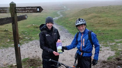
A man from Kendal cycling in rain on Ingleborough last week became the first person to receive a new map of the Pennine Bridleway National Trail.
Phil Atherton, who was in Clapham for work and had decided to take to the hills at lunchtime, said: “I read an article about the Pennine Bridleway and had to see it. Since I was over here, I thought I’d come out to do a little bit more of it. I’ve never had anything given to me like this before.” He has become the first person to receive a new map of the Pennine Bridleway National Trail.
Staff with maps to give away were beginning to question their promotional attempt when Phil Atherton emerged from the drizzle.
The new map is the first to show the entire route of the Pennine Bridleway from the Peak District in Derbyshire to Ravenstonedale in Cumbria.
It has been produced by Harvey Maps with support from the Yorkshire Dales National Park Authority’s Sustainable Development Fund.
The Yorkshire Dales National Park Authority is the lead partner of the Pennine National Trails Partnership, which looks after the route on behalf of Natural England.
Member Champion for Recreation Management at the National Park Authority, Nick Cotton, said: “Thank you to Mr Atherton for being a good sport by posing for a photo and receiving a map. All of us who know the benefits of horse riding, cycling or walking can help spread the word about the Pennine Bridleway. Even in the wet, it’s a great route. Sections of the trail are accessible to those with limited mobility, too.”
He added: “The purpose of making a map which covers the entire Pennine Bridleway is to encourage more people to discover and enjoy the route. As a National Trail it is not yet ten years old, so many people may not have heard of it. It runs through some very high places – a horse rider described it recently as ‘big skies all the way’. It may be a little early to talk of the festivities to come, but the map would make an excellent stocking filler.”
Adam King, HARVEY Maps CEO, said: “It has been a pleasure working with the Pennine National Trails Partnership and the Yorkshire Dales National Park Authority’s Sustainable Development Fund to publish this map which will assist anyone wanting to travel this beautiful and diverse route, on foot, by bike or on horseback. The map is specially designed to enable confident navigation along the way and opens up many more opportunities for use of this multi-purpose trail. This waterproof map covers the entire Pennine Bridleway National Trail with added information on accommodation, planning, places to visit, horsebox parking and more.”


Comments
Add a comment